

Beverly and Qamanirjuaq Range Communities
Cree, Dene, Inuit and Métis peoples across the Beverly and Qamanirjuaq ranges depend on caribou for their culture, food, and livelihoods.
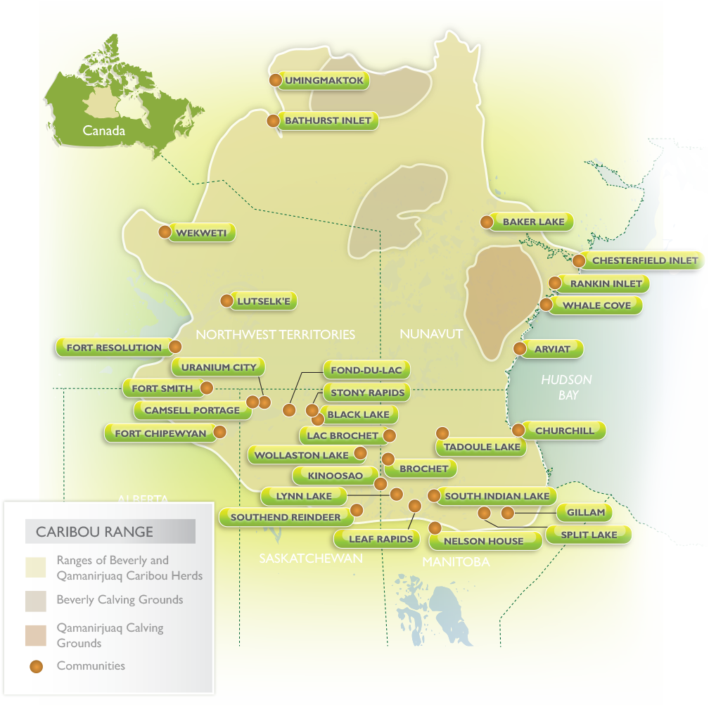

UmingmaktokBathurst InletWekweètiBaker LakeChesterfield InletRankin InletWhale CoveLutsel K’eFort ResolutionArviatUranium CityFond-du-lacFort SmithStony RapidsCamsell PortageBlack LakeFort ChipewyanLac BrochetChurchillTadoule LakeWollaston LakeKinoosaoBrochetLynn LakeSouth Indian LakeSouthendGillamLeaf RapidsNelson HouseSplit Lake
| Caribou Range | |
|---|---|
| Ranges of Beverly and Qamanirjuaq Caribou Herds | |
| Beverly Calving Grounds | |
| Qamanirjuaq Calving Grounds | |

Manitoba
BROCHET
Brochet is a remote area in Northern Manitoba, and is only accessible by plane in the summer season. Adjoining Brochet is the territory of the Barren Lands First Nation called Brochet 197.
Population: 693 (216 Census of Canada)
http://www.brochet.northcentralmb.ca/
School: Brochet School
Tel.: (204) 323-2051
Fax: (204) 323-2053

CHURCHILL
Churchill is a town in northern Manitoba on the west shore of Hudson Bay, roughly 110 kilometres (68 miles) from the Manitoba-Nunavut border. It is most famous for the many polar bears that move toward the shore from inland in the autumn, leading to the nickname “Polar Bear Capital of the World”.
Population: 899 (2016 Census of Canada)
School: Duke of Marlborough School

GILLAM
Gillam is a town on the Nelson River in northern Manitoba. It is situated between Thompson and Churchill on the Hudson Bay Railway line.
Population: 1,265 (2016 Census of Canada)
http://www.townofgillam.com/default.asp
School: Gillam School
Tel.: (204) 652-2193
Fax: (204) 652-2150

Lac BROCHET
Lac Brochet is Dene community in boreal forest of northern Manitoba. The village is located on the north shore of Lac Brochet, and is the administrative centre of the Northlands First Nation.
Population: 816 (2011 Census of Canada)
http://www.ktc.ca/up-coming-events/northlands/
Schools: Petit Casimir Memorial School
Tel.: (204) 337-2278
Fax: (204) 337-2078

LEAF RAPIDS
Leaf Rapids is a town in northwest Manitoba. The community is located approximately 1,000 km north of Winnipeg along the Churchill River.
Population: 582 (216 Census of Canada)
https://en.wikipedia.org/wiki/Leaf_Rapids
Population: 453 (2011 Census of Canada)
Schools: Leaf Rapids Education Centre
Tel.: (204) 473-2403

LYNN LAKE
Lynn Lake, Manitoba, Canada is located 1,071 kilometers northwest of Winnipeg, Manitoba at the end of highway 391. The town of Lynn Lake was founded in 1950, after one the world’s largest nickel deposits was discovered in the area.
Population: 482 (2011 Census of Canada)
Schools: West Lynn Heights School
Tel.: (204) 356-2292
Fax: (204) 356-8297

NELSON HOUSE
Nelson House is an unincorporated community in northern Manitoba, adjacent to the Nelson House 170 Indian Reserve, which is part of the Nisichawayasihk Cree Nation. It is located approximately 75 km (47 mi) northwest of Thompson.
Population: 2,399 (2011 Census of Canada)
Schools:
Nisichawayasihk Neyo Ohtinwak Collegiate (N.N.O.C.)
Tel.: (204) 484-2602
Fax: (204) 484-2612
Otetiskiwin Kiskinwamahtowekamik (O.K.) School
Tel.: (204) 484-2242

SOUTH INDIAN LAKE
South Indian Lake is situated on an arm of the lake that joins South Bay to the main body of the Lake. Approximately two-thirds of the residents are members of the Nelson House Band. The community is about 130 air km northwest of Thompson and is the main settlement of the O-Pipon-Na-Piwin Cree Nation.
Population: 767 (2011 Census of Canada)
https://en.wikipedia.org/wiki/South_Indian_Lake
Schools: Oscar Blackburn School
Tel.: (204) 374-2056
Fax: (204) 374-2052

SPLIT LAKE
Split Lake is a community in Manitoba on the north shore of Split Lake on the Nelson River about 150 miles west southwest of the river’s mouth at Hudson Bay and is within Split Lake 171, a reserve of the Tataskweyak Cree Nation.
Population: 2,107 (2011 Census of Canada)
Schools: Chief Sam Cook Mahmuwee Education Centre
Tel.: (204) 342-2134
Fax: (204) 342-2139

TADOULE LAKE
Tadoule Lake is an isolated northern community in Manitoba reachable by plane, snowmobile, dog team sleds, and in winter by winter road. It is home to the Sayisi Dene First Nation.
Population: 772 (2016 Census of Canada)
http://www.ktc.ca/up-coming-events/sayisi-dene/
Schools: Peter Yassie Memorial School
Tel.: (204) 684-2279
Fax: (204) 684-2130

YORK LANDING
York Landing, Manitoba is a community located along the eastern bank of the Nelson River, roughly halfway between Lake Winnipeg and Hudson Bay, and 116 kilometres from Thompson, Manitoba. It is home to the York Factory Cree Nation.
Population: 1,239
http://www.ktc.ca/up-coming-events/factory-first/
Schools: George Saunders Memorial School
Tel.: (204) 341-2118
Fax: (204) 341-2235

Nunavut
ARVIAT
Arviat is the southernmost community on the Nunavut mainland and is close to the geographical centre of Canada. In Arviat, Inuktitut and English are primarily spoken, having the third largest population in Nunavut, behind Rankin Inlet and Iqaluit. Arviat is located on the western shores of Hudson Bay, approximately 200km north of Churchill, Manitoba.
Population: 2,657 (2016 Census of Canada)
Want to learn more about the people of Arviat? Start by visiting the Voices of the Caribou page.
Schools:
Levi Angmak Elementary School
Tel.: (867) 857-2547
Fax: (867) 857-2656
Qitiqliq Middle School
Tel.: (867) 857-2778
Fax: (867) 857-2669
John Arnalukjuak High School
Tel.: (867) 857-4223
Fax: (867) 857-4221
Nunavut Arctic College
Tel.: (867) 857-2903
Fax: (867) 857-2928

BAKER LAKE
Baker Lake is a hamlet in the Kivalliq Region in Nunavut. Located 320 km (200 mi) inland from Hudson Bay, it is near the nation’s geographical centre, and is notable for being the Canadian Arctic’s sole inland community.
Population: 2,069 (2016 Census of Canada)
Schools:
Rachel Arngnammaktiq Elementary School
Tel.: (867) 793-2513
Fax: (867) 793-2500
Jonah Amitnaaq Secondary School
Tel: (867) 793-2842
Fax: (867) 793-4659
Nunavut Arctic College
Tel.: (867) 793-2971
Fax: (867) 793-2181

BATHURST INLET
Bathurst Inlet is a small Inuit community located in Bathurst Inlet in the Kitikmeot Region of Nunavut, Canada. As of the 2016 census the population remained at zero.

CHESTERFIELD INLET
The Municipality of Chesterfield Inlet is located in Nunavut, just south of the Arctic Circle in Northern Canada on the west coast of Hudson Bay.
chesterfield-inlet.ca
Population: 437 (2016 Census of Canada)
Schools:
Victor Sammurtok
Tel.: (867) 898-9913
Fax: (867) 898-9143
Back to Map
Nunavut Arctic College
Tel.: (867) 898-9048
Fax: (867) 898-9101

RANKIN INLET
Located on the west coast of Hudson Bay about 300 km north of Churchill, Rankin Inlet is the transportation, health services, and business centre of the Kivalliq Region of Nunavut.
Population: 2,842 (2016 Census of Canada)
Schools:
Leo Ussak Elementary School
Tel.: (867) 645-2814
Fax: (867) 645-2333
Maani Ulujuk Ilinniarvik School
Tel.: (867) 645-2761
Fax: (867) 645-2209
Simon Alaittuq High School
Tel.: (867) 645-2780
Fax: (867) 645-2933
Nunavut Arctic College, Kivalliq Campus
Tel.: (867) 645-5500
Fax: (867) 645-2387
Nunavut Arctic College, Community Learning Centre
Tel.: (867) 645-2917
Fax: (867) 645-2198
Back to Map

UMINGMAKTOK
Umingmaktok is a now abandoned settlement located in Bathurst Inlet in the Kitikmeot Region of Nunavut. The community was previously known as Bay Chimo and the Inuit refer to the community as Umingmaktuuq (“like a musk ox”).
Population: 0 (2016 Census of Canada)
Schools:
Tel.:
Fax:
Back to Map

WHALE COVE
Whale Cove is located on the western coast of Hudson Bay, north of Arviat and south of Kivalliq’s central community, Rankin Inlet. It is named for the abundance of Beluga whales that congregate in nearby waters every fall.
Population: 435 (2016 Census of Canada)
Schools:
Inuglak School
Tel.: (867) 896-9300
Fax: (867) 896-9005
Nunavut Arctic College
Tel.: (867) 896-9166
Fax: (867) 896-9166

Northwest Territories
FORT RESOLUTION
Fort Resolution is a hamlet in the South Slave Region of the Northwest Territories, Canada. The community is situated at the mouth of the Slave River, on the shores of Great Slave Lake, and at the end of the Fort Resolution Highway (Highway 6).
Population: 470 (2016 Census of Canada)
https://spectacularnwt.com/destinations/south-slave/communities/fort-resolution
Schools:
Aurora College – Community Learning Centre
Tel.: (867) 394-5401
Fax: (867) 394-3181
Deninu School
Tel.: (867) 394-4501
Fax: (867) 394-3201

FORT SMITH
Population: 2,542 (2016 Census of Canada)
Schools:
Aurora College – Thebacha Campus
Tel.: (867) 872-7500
Fax: (867) 872-4511
J.B.T. Elementary School
Tel.: (867) 872-3999
Fax: (867) 872-2448
P.W. Kaeser High School
Tel.: (867) 872-4795
Fax: (867) 872-3039

LUTSEL K’E
Łutsel Kʼe is a “designated authority”in the North Slave Region of the Northwest Territories, Canada. The community is located on the south shore near the eastern end of Great Slave Lake and until 1 July 1992, it was known as Snowdrift, as the community lies near the mouth of the Snowdrift River.
Population: 303 (2016 Census of Canada)
Want to learn more about the people of Lutsel K’e? Start by visiting the Voices of the Caribou page.
Schools:
Lutsel K’e Dene School
Tel.: (867) 370-3131
Fax: (867) 370-3017

WEKWEETI
Wekweètì is a community in the North Slave Region of the Northwest Territories, Canada. Wekweètì is a Tłı̨chǫ (Dogrib Dene) aboriginal community and is located 195 km (121 mi) north of Yellowknife.
https://www.tlicho.ca/community/wekweeti
Population: 129 (2016 Census of Canada)
Schools: Alexis Arrowmaker School
Tel.: (867) 713-2100

Saskatchewan
BLACK LAKE
Black Lake Denesuline First Nation (Black Lake) is a community located in Northern Saskatchewan’s Athabasca Basin region, approximately 1,180 km northwest of Prince Albert.
https://blacklakefirstnation.ca
Population: 1,070 (2011 Census of Canada)
Schools:
Father Porte Dene Memorial School
Tel.: (306) 284-2166
Fax: (306) 284-2080

CAMSELL PORTAGE
Camsell Portage is a northern settlement located on the north-central shore of Lake Athabasca. The northern settlement is an unincorporated community in the Northern Saskatchewan Administration District. Camsell Portage is about 14 km (8.7 mi) west of the Waterloo Lake camp and 36 km (22 mi) west of Uranium City by air via Camsell Portage Airport.
www.kayas.ca/communities/camsell/camsell.html
Population: 37

FOND DU LAC
Fond Du Lac Denesuline First Nation is situated between the communities of Uranium City in the west and Stony Rapids to the east. It is accessible by air year round, by boat in the summer and by an ice road in winter that connects it with Stony Rapids. Fond Du Lac is one of the three Denesuline First Nations of Prince Albert Grand Council and one of the nine in the province of Saskatchewan under the umbrella of Federation of Saskatchewan Indian Nations.
Population: 874 (2011 Census of Canada)
Schools:
Father Gamache School
Tel.: (306) 686-2033
Fax: (306) 686-2110

KINOOSAO
www.peterballantyne.ca/communities.kinoosao.html
Population: 40 (2011 Census of Canada)

SOUTHEND
Southend is a community in north eastern Saskatchewan, Canada located at the southern end of Reindeer Lake, the ninth largest lake in Canada. The community is the terminus of Highway 102 and is 221 km (137 miles) north east of La Ronge.
The community consists of the northern settlement of Southend and Southend 200, a reserve of the Peter Ballantyne Cree Nation.
Population: 904 (2011 Census of Canada)
Schools: Reindeer Lake School
Tel.: (306) 758-2180

STONY RAPIDS
Population: 243 (2011 Census of Canada)
Schools:
Stony Rapids School
Tel.: (306) 439-2123
Fax: (306) 439-2032

URANIUM CITY
Uranium City is a northern settlement in northern Saskatchewan, Canada. Located on the northern shores of Lake Athabasca near the border of the Northwest Territories, it is 230 m (750 ft) above sea level. The settlement is 760 km (470 mi) northwest of Prince Albert, 760 km (470 mi) northeast of Edmonton and 48 km (30 mi) south of the Northwest Territories-Saskatchewan boundary.
Population: 73 (2016 Census of Canada)
Schools:
Ben McIntyre School
Tel.: (306) 498-2150
Fax: (306) 498-3130

WOLLASTON LAKE
Hatchet Lake Dene Nation is a Dene First Nation in northern Saskatchewan. The main settlement, Wollaston Lake, is an unincorporated community on Wollaston Lake in the boreal forest of northeastern Saskatchewan, Canada.
Population: 1,251 (2016 Census of Canada)
Schools:
Father Megret Elementary School
Tel.: (306) 633-2222
Fax: (306) 633-4888
Father Megret High School
Tel.: (306) 633-2205

Alberta
FORT CHIPEWYAN
Fort Chipewyan, commonly referred to as Fort Chip, is a hamlet in northern Alberta, Canada. It is located on the western tip of Lake Athabasca, adjacent to Wood Buffalo National Park, approximately 223 kilometres (139 mi) north of Fort McMurray.
www.rmwb.ca/living/communities/fort-chipewyan.htm
Population: 852 (2016 Canada Census)
Schools: Athabasca Delta Community School
Tel.: (780) 697-3933
Fax: (780) 697-3604